Walking tour: Camp Turenne and Wolfsfkopf  

1 rue Latouche
68700 Cernay
Location

Nearest train station :
2 km - Cernay

Catering on spot : Restaurant

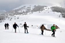
Departing from Cernay, this hike more athletic than the others goes around the Wolfskopf, towards the Herrenfluh and Camp Turenne passes. Passing through the villages at the foot of the Peaks Route, some remains of WWI will be revealed at the bend of the road. Nevertheless, the Vosges are steep!

Photo gallery


©OTTC
©CCTC
 OTTC_Angélique_Bindler
©Marc-Antoine-Weber

About the walk


  path
  Start : Cernay - Parking de la Porte de Thann
  Altitude difference : 610 m
  Length : 18 Km

Useful information


  historical/heritage path
  hiking path
  IGN walking map needed : 1/25000 3620 ET
  Marking :

Besoin d'informations ?
Retrouvez nos brochures !

Proposer
Une manifestation

Une question ?
Contactez-nous !

Besoin d'informations ?
Retrouvez nos brochures !

Retrouvez-nous aussi sur

Une question ?
Contactez-nous !

Maps & brochures ?
Free download !

Follow us on

A question ?
Contact us !

Tourist office in Saint Amarin


81, rue Charles de Gaulle - 68550 SAINT-AMARIN
Monday to Saturday from 10 to 12 am and from 3 to 5 pm - On Sundays and bank holidays from 10 to 12 am.

En poursuivant votre navigation sur ce site vous acceptez l'utilisation des cookies.